File:A home on Loktak Lake Moirang Manipur India.jpg
From Wikimedia Commons, the free media repository
Jump to navigation
Jump to search

Size of this preview: 800 × 531 pixels. Other resolutions: 320 × 213 pixels | 640 × 425 pixels | 1,024 × 680 pixels | 1,280 × 850 pixels | 2,560 × 1,700 pixels | 4,288 × 2,848 pixels.
Original file (4,288 × 2,848 pixels, file size: 2.09 MB, MIME type: image/jpeg)
File information
Structured data
Captions
Captions
Add a one-line explanation of what this file represents
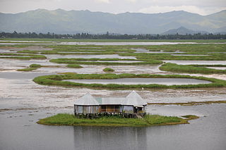
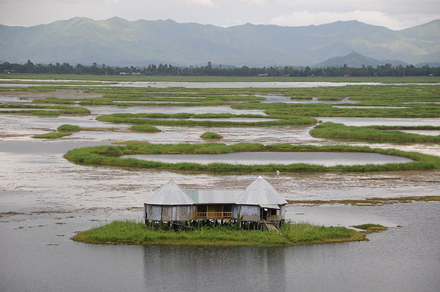
DescriptionA home on Loktak Lake Moirang Manipur India.jpg | Lakes and mountains of Manipur | ||
Date | |||
Source | Flickr: CSP_4615.JPG | ||
Author | Sharada Prasad CS | ||
Permission (Reusing this file) |
![]() ![]() This file is licensed under the Creative Commons Attribution 2.0 Generic license.
|
Camera location | 24° 30′ 52.45″ N, 93° 47′ 39.06″ E ![]() ![]() | View this and other nearby images on: OpenStreetMap | ![]() |
---|
File history
Click on a date/time to view the file as it appeared at that time.
Date/Time | Thumbnail | Dimensions | User | Comment | |
---|---|---|---|---|---|
current | 00:18, 20 June 2014 | ![]() | 4,288 × 2,848 (2.09 MB) | Flickr upload bot (talk | contribs) | Uploaded from http://flickr.com/photo/11124467@N02/3397975930 using Flickr upload bot |
You cannot overwrite this file.
File usage on Commons
There are no pages that use this file.
File usage on other wikis
The following other wikis use this file:
- Usage on as.wikipedia.org
- Usage on bn.wikipedia.org
- Usage on bn.wikivoyage.org
- Usage on de.wikipedia.org
- Usage on en.wikipedia.org
- Usage on en.wikivoyage.org
- Usage on fr.wikipedia.org
- Usage on hi.wikipedia.org
- Usage on it.wikipedia.org
- Usage on ml.wikipedia.org
- Usage on mr.wikipedia.org
- Usage on ne.wikipedia.org
- Usage on or.wikipedia.org
- Usage on pa.wikipedia.org
- Usage on pl.wikipedia.org
- Usage on pnb.wikipedia.org
- Usage on ru.wikipedia.org
- Usage on uk.wikipedia.org
- Usage on ur.wikipedia.org
Metadata
This file contains additional information such as Exif metadata which may have been added by the digital camera, scanner, or software program used to create or digitize it. If the file has been modified from its original state, some details such as the timestamp may not fully reflect those of the original file. The timestamp is only as accurate as the clock in the camera, and it may be completely wrong.
Camera manufacturer | NIKON CORPORATION |
---|---|
Camera model | NIKON D300 |
Exposure time | 1/320 sec (0.003125) |
F-number | f/5.3 |
ISO speed rating | 200 |
Date and time of data generation | 16:12, 3 July 2008 |
Lens focal length | 90 mm |
User comments | CS Sharada Prasad (CSP) |
Latitude | 24° 30′ 52.45″ N |
Longitude | 93° 47′ 39.05″ E |
Altitude | 783 meters above sea level |
Orientation | Normal |
Horizontal resolution | 300 dpi |
Vertical resolution | 300 dpi |
Software used | Ver.1.00 |
File change date and time | 16:12, 3 July 2008 |
Y and C positioning | Co-sited |
Exposure Program | Aperture priority |
Exif version | 2.21 |
Date and time of digitizing | 16:12, 3 July 2008 |
Meaning of each component |
|
Image compression mode | 1 |
APEX exposure bias | −0.33333333333333 |
Maximum land aperture | 4.8 APEX (f/5.28) |
Metering mode | Pattern |
Light source | Unknown |
Flash | Flash did not fire |
DateTime subseconds | 56 |
DateTimeOriginal subseconds | 56 |
DateTimeDigitized subseconds | 56 |
Supported Flashpix version | 1 |
Color space | sRGB |
Sensing method | One-chip color area sensor |
File source | Digital still camera |
Scene type | A directly photographed image |
Custom image processing | Normal process |
Exposure mode | Auto exposure |
White balance | Auto white balance |
Digital zoom ratio | 1 |
Focal length in 35 mm film | 135 mm |
Scene capture type | Standard |
Scene control | None |
Contrast | Normal |
Saturation | Normal |
Sharpness | Normal |
Subject distance range | Unknown |
GPS time (atomic clock) | 10:41 |
Satellites used for measurement | 09 |
Reference for direction of image | Magnetic direction |
Direction of image | 256.5 |
Geodetic survey data used | WGS 84 |
GPS date | 3 July 2008 |
GPS tag version | 2.2.0.0 |